
There’s a group of people who, in recent years, have dug up facts about Fairfax County history. Check out this summary of what Fairfax County archaeologists and volunteers have found at Old Colchester Park and Preserve.
 Old Colchester Park and Preserve is in southern Fairfax County. The Fairfax County Park Authority (FCPA) acquired the 150-acre wooded area in 2006. It’s a strategic location near the junction of the Occoquan and Potomac Rivers and along the main land route travelers used when passing through early Virginia. That location makes this area rich with history.
Archaeological investigations completed by the FCPA’s Colchester Archaeological Research Team (CART) at Old Colchester Park during 2013 uncovered a stone foundation and a multitude of artifacts which date to the later part of the 18th century. The park soon will have walking trails with informational panels about the various natural and cultural resources that are there.
CART has a blog for weekly informational posts about Old Colchester Park artifacts, archaeology happenings and lab processing.
Colchester was established in 1753. It was a small shipping town which moved tobacco and other goods from farms further upriver to markets along the Chesapeake Bay and beyond. There’s a 3-D model of what Colchester looked like around 1820 that illustrates the area’s structures such as barns, houses, warehouses and ordinaries. You can see it through a virtual tour online.
Blacksmiths, coopers, sailors, a vintner and tobacco inspectors lived and worked in the town during its heyday, but moved away by the 1840s when the port silted in and trade became more difficult.

Click on the photo to take a 3-D, virtual tour of Old Colchester.
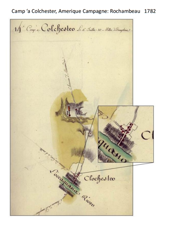 During the Revolutionary War, French General Jean Baptiste de Rochambeau passed through the area of Colchester in 1781 and 1782, crossing the Occoquan River and passing through the town of Colchester. His map notes the Occoquan River and Colchester along with a camp north of the town. The map contains no scale, but structures were noted along the intersection of Furnace Road and Old Colchester Road. The town of Colchester was well established by the last quarter of the 18th century, so the buildings could represent homes and other structures, which Rochambeau drew to mark the busy port town.
The nearby Enyedi property is a 1.45 acre tract of land on the north side of Old Colchester Road near the intersection of Old Colchester Road and Furnace Road. The Park Authority acquired it in 2012. Located on this property are a large metal barn, a house, and a small shed. The core of the house dates to the 1870s, and it was built by a family named Clark. Archaeologists recovered various artifacts and 18th century concentrations of artifacts near the house and near the intersection of Furnace Road and Old Colchester Road.
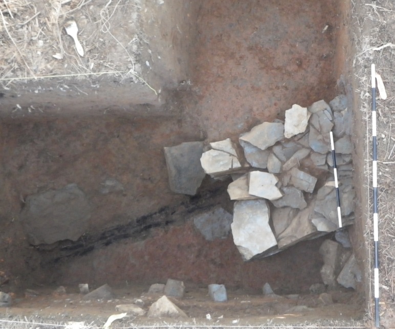 In a place like Old Colchester Park or on the Enyedi property, archaeologists explore small sample areas in great detail. For example, they excavate a one-meter-by-one-meter area on hands and knees with the smallest of tools. When full meter-by-meter test units were opened in the Enyedi property, they discovered a stone wall. Each layer of the fill near the stone wall contained mortar, slate, window glass and brick fragments that indicated the material that was used to build the structure. The bottom of the feature fill was about a meter below the ground surface and exposed a charred structural timber there along with the stone wall. That led interpreters to note that this structure at the corner of Furnace Road and Old Colchester Road is similar to a structure still standing which was built as an ordinary for the Town of Colchester.
Wrought nails, glass and ceramics, including creamware, pearlware, tin glaze and agateware, were the majority of the artifacts recovered, and the deposit was dated to the 18th century. A large metal hinge was recovered near the bottom of the feature fill. This hinge is over a meter long and contained six hand wrought nails, some of them clinched at the end. A hinge of this size would be used for large doors like a barn door or, possibly, a large cellar door to a bulk head entrance.

Artifacts of bone, ceramics, glass, and nails recovered during CART excavations in 2012.
This is where archaeologists put their discoveries in perspective and become interpreters. They have a map of the area from 1782 with a stone foundation marked on it. That foundation was capped and filled with layers which date to the late 18th or early 19th century. The foundation’s building was erected alongside a colonial port town with the same foundation construction as a standing historic building. All of this leads to the conclusion that the stone wall is associated with another domestic dwelling that was used about 1753 to 1840. More information about the function and full size of the structure will need future archaeological research, as only two meters were exposed during a 2012 excavation by CART. A small excavation under the pines, at the intersection of Old Colchester Road and Furnace Road, has answered some questions and, of course, raised more questions about the historic happenings within southern colonial Fairfax County.
Author Megan Veness is the Field Director for the Colchester Archaeological Research Team working at Old Colchester Park and Preserve.
